Urban Heat Island Impact Calculator
Calculate Your Neighborhood's Cooling Potential
How much heat reduction could green infrastructure make in your community? Calculate how trees and other cooling solutions can lower temperatures and improve health outcomes.
Results
Enter your data and click 'Calculate' to see your neighborhood's potential cooling benefits.
Important Note: The article explains that the most vulnerable communities often have the least green space. Your calculation shows potential cooling effects, but equitable distribution of green infrastructure is critical for health equity.
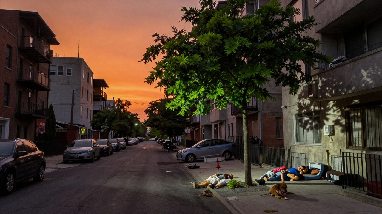
When Your City Feels Like an Oven
It’s 9 p.m. in July. You’ve turned off the AC, hoping the night air will cool things down. But it doesn’t. The pavement outside still radiates heat. Your neighbors are sleeping on the floor. Someone’s dog is panting in the hallway. This isn’t just a hot summer night-it’s the urban heat island effect, and it’s killing people.
Urban areas can be up to 12°C hotter than nearby rural land, especially at night. That’s not a minor difference. It’s the difference between life and death for older adults, kids, and people without access to cooling. In cities like Phoenix, Paris, or Delhi, heat waves are no longer rare events. They’re annual threats. And the worst part? The neighborhoods hit hardest aren’t the ones with the fanciest buildings-they’re the ones with the least trees, the oldest housing, and the lowest incomes.
Why Cities Get So Hot
Think about what cities are made of: asphalt, concrete, steel, glass. These materials soak up sunlight like sponges. During the day, they store heat. At night, they slowly release it. Meanwhile, natural surfaces-trees, grass, soil-cool the air through shade and evaporation. But in many urban areas, green space has been replaced by parking lots and rooftops.
It’s not just about materials. The shape of the city matters too. Tall buildings lined up close together create "urban canyons." These trap hot air, block wind, and prevent cooling. A study by VITO and ECMWF in 2023 showed that neighborhoods with narrow streets and dense high-rises can be 4-6°C hotter than nearby open areas-even if they’re only a few blocks apart.
And it’s getting worse. As global temperatures rise, cities are heating up faster than ever. The University of Michigan found that, on average, cities are 5.5°C warmer than surrounding natural land. In some places, like parts of Chicago or Los Angeles, the gap is even bigger-up to 7°C in low-income areas. Why? Because decades of redlining meant those neighborhoods got fewer trees, fewer parks, and more industrial zones.
The Health Cost of Hot Streets
Heat doesn’t just make you uncomfortable. It makes you sick. When temperatures climb above 30°C (86°F), the body struggles to regulate itself. Elderly people, young children, and those with heart or lung conditions are especially at risk. Heat exhaustion, dehydration, kidney failure, and even heart attacks spike during heat waves.
The European Centre for Medium-Range Weather Forecasts projected that, even under the best-case climate scenario, heat-related deaths in European cities could rise 8 to 10 times by 2050. Under worse scenarios? Up to 30 times. That’s not a prediction-it’s a countdown.
But it’s not just direct heat. Hotter cities mean worse air quality. Higher temperatures speed up the chemical reactions that turn vehicle exhaust and industrial emissions into ground-level ozone-the main ingredient in smog. In cities like Atlanta and Madrid, ozone levels have jumped 15-20% over the past decade. People with asthma see more emergency visits. Kids miss more school. Older adults are hospitalized more often.
And here’s the cruel twist: the people most affected are the ones least able to escape it. In Philadelphia, a 2021 study found that neighborhoods with the highest heat exposure had 30% fewer trees and 40% higher rates of diabetes and hypertension. In Houston, low-income residents were 2.5 times more likely to die during heat waves than wealthier neighbors-even when controlling for age and health.
Green Infrastructure Isn’t Just Pretty-It’s Life-Saving
There’s a solution that’s simple, cheap, and effective: more nature in the city. Green infrastructure means planting trees, creating parks, installing green roofs, and restoring wetlands. But it’s not just about beauty. It’s about survival.
Trees are the most powerful tool we have. A single mature tree can cool the air around it by up to 5°C through shade and evaporation. In neighborhoods with 30% tree cover, summer temperatures drop noticeably. In Los Angeles, the city is planting 90,000 trees by 2030 in areas that used to have almost none. Why? Because they’ve mapped the heat. They know exactly where the hottest spots are-and who lives there.
Green roofs and walls work too. A study by the EPA showed that cool roofs-painted white or covered in vegetation-can lower surface temperatures by 28-33°C. That’s huge. But here’s the catch: cool roofs alone don’t fix the social gap. If only wealthy neighborhoods get them, the problem just shifts. That’s why cities like New York now require cool roofs on all new buildings. And why Chicago ties tree-planting funding to income levels, not just geography.
Green infrastructure also cleans the air. Plants absorb pollutants like nitrogen dioxide and particulate matter. In London, a 2022 study found that a 10% increase in urban tree cover reduced PM2.5 levels by 8%. That’s equivalent to taking 20,000 cars off the road.
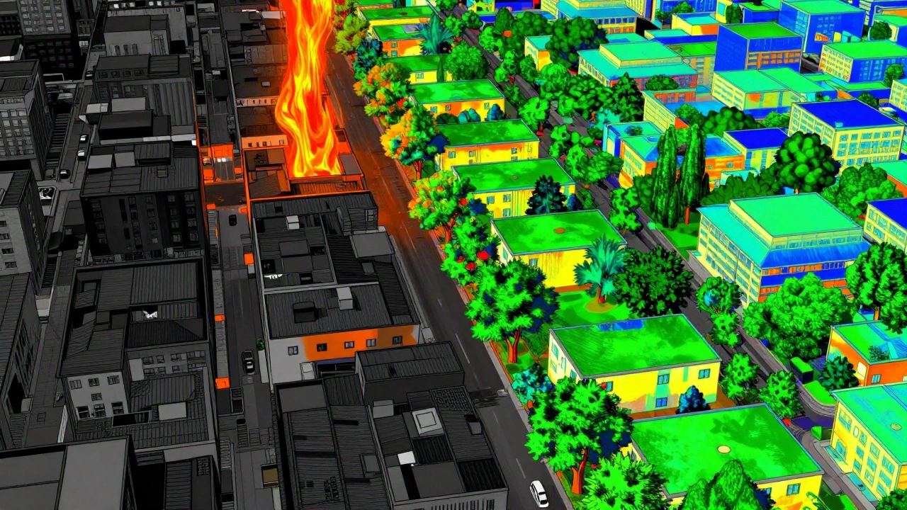
Technology Is Helping Us See the Invisible
For years, cities guessed where heat was worst. Now, they know. Digital twins-virtual 3D models of entire cities-are changing everything. Siradel and other urban tech firms use satellite data, weather sensors, and census information to create heat maps that show exactly where temperatures spike and who’s at risk.
These models don’t just show heat. They layer in data on age, income, health conditions, and housing type. One city in Germany used this approach to find that 62% of heat-related hospital visits came from just 8% of its neighborhoods. That’s not random. That’s systemic. And now, they’re targeting resources there-planting trees, installing cooling shelters, training community health workers.
Machine learning predicts heat vulnerability with 95% accuracy by 2025. That means cities can act before people get sick. They can open cooling centers before the next heat wave. They can send out water and health alerts to the right people at the right time.
Who’s Doing It Right?
Some cities are leading the way. Madrid’s "Superblocks" program closed off entire neighborhoods to cars and turned them into green public spaces. Temperatures dropped by 2-3°C within two years. Singapore plants trees on every available surface-bridges, highways, even parking garages. Their goal? 50% tree cover by 2030.
In the U.S., Los Angeles is legally required to plant 90,000 trees by 2040, with priority given to neighborhoods with the least canopy. New York City now mandates cool roofs on all new buildings. And in Portland, the city uses a "heat equity index" to decide where to spend its green infrastructure budget. The neighborhoods with the highest heat risk and lowest income get the most funding.
Europe is investing heavily too. The EU has pledged €1.2 billion through 2027 to boost urban greenery. The World Bank is putting $2.8 billion into heat resilience projects in Africa and Asia, where cities are growing fastest and least prepared.
It’s Not Just About Trees-It’s About Justice
Green infrastructure isn’t a technical fix. It’s a social one. You can’t plant a tree and call it a day if the people living nearby still can’t afford AC, or don’t have access to healthcare, or are too afraid to open windows because of crime.
Dr. Wen-Ching Chow at the University of Michigan says it plainly: "Vulnerable communities lack the economic assets, social support, and physical capacity to respond to heat." That’s why successful programs don’t just plant trees-they hire local residents to maintain them. They train community leaders to recognize heat symptoms. They connect residents to cooling centers and water distribution points.
One program in Philadelphia paired tree planting with home energy audits. They installed fans, weatherstripping, and blackout curtains in homes of elderly residents. Result? Heat-related ER visits dropped by 40% in two summers.
What Happens If We Do Nothing?
By 2050, nearly 70% of the world’s population will live in cities. That’s 2.5 billion more people, most of them in places already overheating. Without action, heat deaths could become the leading cause of weather-related mortality worldwide.
Insurance companies are already reacting. Swiss Re reported in 2023 that homes in high-heat zones face 15-18% higher premiums. Property values are dropping in areas with no shade. Businesses are relocating. Workers are missing days because it’s too hot to be outside.
The cost of inaction isn’t just human. It’s economic. The global urban resilience market is worth $43.2 billion-and growing at 11.7% a year. Heat mitigation makes up nearly a quarter of that. Cities that invest now will save money later. Those that wait will pay in lives and dollars.
What Can You Do?
You don’t need to be a mayor to make a difference. If you live in a city:
- Plant a tree-or help your neighborhood plant one.
- Ask your city council for a heat vulnerability map and a green infrastructure plan.
- Support policies that require cool roofs, tree planting, and shade in public spaces.
- Check on elderly neighbors during heat waves. Bring them water. Turn on their AC if they can’t.
- Vote for leaders who treat heat as a public health emergency, not a weather report.
Urban health resilience isn’t about technology or money. It’s about who we choose to protect. And right now, we’re choosing the wrong people.
What exactly is an urban heat island?
An urban heat island is when a city becomes significantly warmer than nearby rural areas due to human-made surfaces like asphalt, concrete, and buildings that absorb and trap heat. At night, temperatures in cities can be up to 12°C higher than in surrounding countryside, especially in areas with little vegetation.
How do green spaces help reduce heat in cities?
Trees and plants cool the air through shade and evaporation. A single mature tree can lower nearby air temperatures by up to 5°C. Parks, green roofs, and street trees also reduce the amount of heat absorbed by buildings and pavement, making neighborhoods noticeably cooler during heat waves.
Why do low-income neighborhoods suffer more from heat islands?
Historical policies like redlining led to fewer trees, fewer parks, and more industrial land in low-income areas. These neighborhoods often have older housing with poor insulation, limited access to air conditioning, and fewer public cooling centers. As a result, they experience higher temperatures and greater health risks during heat events.
Can cool roofs really make a difference?
Yes. Cool roofs-painted white or covered in vegetation-can reduce surface temperatures by 28-33°C compared to traditional dark roofs. While they don’t cool the air as much as trees, they reduce building energy use and lower indoor temperatures, which helps prevent heat-related illness.
Is urban heat only a problem in summer?
No. While heat waves are most dangerous in summer, urban heat islands exist year-round. At night, cities retain heat longer than rural areas, making it harder for people to recover from daytime exposure. In winter, the extra heat can increase energy demand and air pollution from heating systems.
How do digital twins help fight urban heat?
Digital twins are virtual models of cities that combine temperature data, population demographics, and building materials to identify heat hotspots and vulnerable populations. They let city planners test different interventions-like planting trees or painting roofs-before spending money, making solutions more targeted and effective.
What’s the link between heat and air quality?
Higher temperatures speed up chemical reactions that create ground-level ozone, the main component of smog. This worsens asthma, bronchitis, and other lung conditions. Hot cities also see more wildfires and dust, which add harmful particles to the air. So heat doesn’t just raise body temperature-it also makes breathing harder.
Are there any laws or policies addressing urban heat?
Yes. New York City requires cool roofs on all new buildings. Los Angeles mandates 40% tree canopy in vulnerable neighborhoods by 2040. The European Union has committed €1.2 billion to urban greening by 2027. Many cities now include heat resilience in their climate action plans and require equity assessments before funding green projects.